VEXRAD • Geothermal Exploration
Geothermal Exploration Methods: De-Risk the Reservoir Before Drilling
A geothermal prospect is more than a hot rock. A successful well needs the right combination of heat, geology, permeability and fluid — at a location that can be drilled and developed economically.
What are explorers looking for?
Heat is necessary. It is not sufficient.
Heat
Is the subsurface hot enough at an economically accessible depth for the intended power or heat application?
Permeability
Are faults, fractures or permeable formations capable of supporting the required fluid movement?
Fluid & connectivity
Is usable fluid present, and does the reservoir geometry support sustainable production and reinjection?
The objective is therefore not simply to find a temperature anomaly. It is to construct a defensible subsurface model and select the next well location with the best available evidence.
The geothermal exploration toolkit
Methods answer different parts of the reservoir question.
| Method | What it contributes | Typical geothermal use | Key limitation |
|---|---|---|---|
| Geological mapping | Lithology, faults, structures and geological history | Build the structural framework and geothermal concept | Deep conditions must be inferred where exposure/control is limited |
| Geochemistry | Fluid chemistry, isotopes and geothermometry | Constrain fluid source, flow paths and possible subsurface temperature | Hidden systems may have little or no surface fluid expression |
| Remote sensing | Surface mineral, thermal and structural information | Regional screening, alteration and structural mapping | Primarily surface evidence |
| Gravity | Density contrasts | Basins, faults, intrusions and regional architecture | Interpretation is non-unique |
| Magnetics | Magnetic-property contrasts | Structure, lithology and alteration patterns | Magnetic response does not directly measure temperature or permeability |
| MT / AMT | Electrical resistivity structure | Deep conductive/resistive architecture, clay caps and reservoir context | Resolution decreases with depth and interpretation is not unique |
| Seismic | Elastic/velocity contrasts and seismicity | Faults, fractures, structures and reservoir geometry | Acquisition and processing can be complex and costly |
| Temperature-gradient / heat-flow data | Direct or constrained thermal information | Confirm geothermal gradient and heat-flow context | Direct measurements generally require boreholes |
| ADR / VEXRAD | Depth-referenced energy, frequency, dielectric and related responses | Virtual Boreholes, lithological interpretation, boundaries and candidate reservoir/permeability intervals | Project-specific interpretation; benefits from calibration and independent validation |
| Exploration drilling | Direct geological, temperature, fluid and well-test evidence | Confirm the resource and reservoir | Capital-intensive point information |
Method performance is site-specific. Survey design should follow the geological setting, reservoir concept, depth and decision being made.
An integrated workflow
From regional prospect to drill-ready target.
Why pre-drill intelligence matters
The well is where exploration risk becomes capital risk.
Deep drilling can represent a major share of geothermal project cost. Better subsurface characterisation cannot remove geological uncertainty, but it can improve the basis on which expensive well locations are selected.
Before drilling
- Compare alternative well locations
- Test the structural and lithological model
- Look for evidence associated with permeability
- Integrate independent datasets
- Define explicit success criteria
After drilling
- Compare prediction with the physical well
- Update the geological model
- Calibrate subsequent interpretation
- Improve production/reinjection targeting
- Turn the first well into learning for the next
Where VEXRAD fits
A Virtual Borehole before the physical borehole.
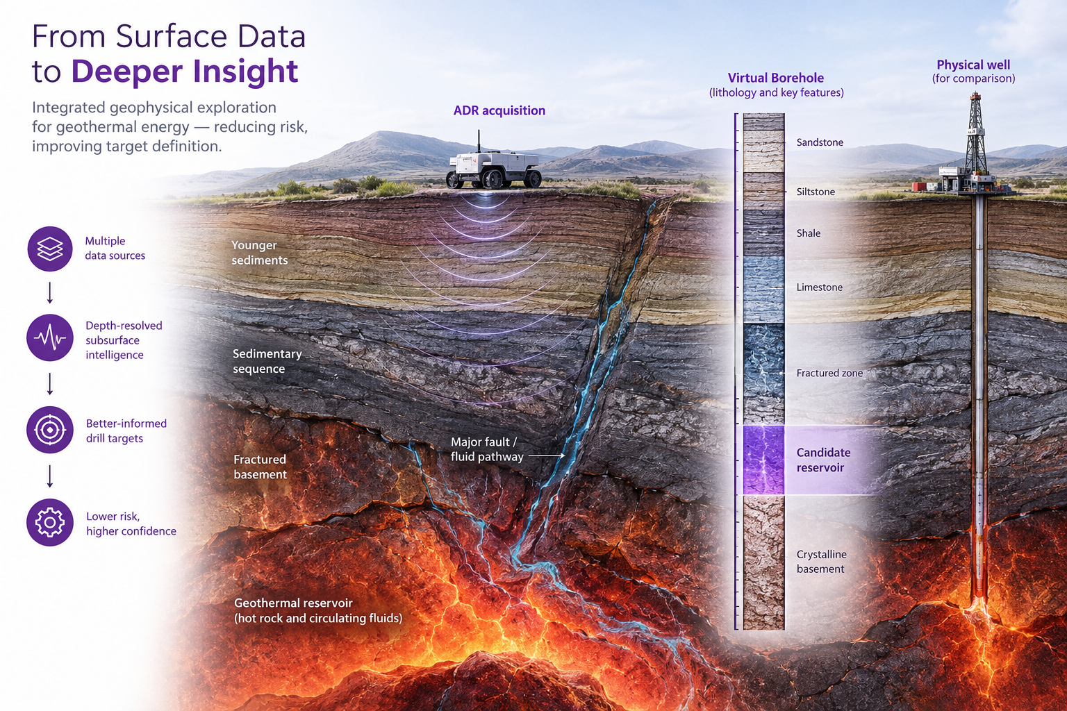
VEXRAD uses Atomic Dielectric Resonance (ADR) to acquire electromagnetic measurements from surface and process them into depth-referenced subsurface interpretations. For geothermal exploration, the aim is to add another evidence layer around lithology, boundaries, structures and candidate intervals before a physical well is committed.
1. Integrate
Start with the existing geology, geochemistry, geophysics, seismic, wells and reservoir concept.
2. Investigate
Acquire ADR at selected locations and construct depth-referenced Virtual Boreholes.
3. Validate
Rank interpreted intervals and compare predictions with drilling or other independent ground truth where available.
Surface acquisition
ADR measurements acquired at the proposed target location.
Layered geology
Structures • boundaries • changing subsurface response
Depth-referenced output
Virtual Borehole
Interpret lithological changes, boundaries, structures and intervals of interest before committing to a physical well.
Then test it:
Prediction → drilling → independent comparison → model update.
Evidence in practice
United Downs: a prediction made before a ~5 km geothermal well.
Before deep drilling
Predicted from ADR
Later comparison
Pre-drill ADR prediction later tested against UD-1
At United Downs in Cornwall, ADR Virtual Borehole UD-C2 was acquired in November 2014, before the deep geothermal well was drilled. The published VEXRAD validation compares three candidate permeable intervals predicted from the ADR response with later public well information. Two of the three predicted zones fall within the well’s reported major mud-loss intervals.
Important limitation: this is one Virtual Borehole validation. Permeability was inferred from mud-loss information rather than directly measured, and not every ADR parameter correlated equally well.
Questions to ask before drilling
Turn the reservoir concept into testable questions.
Subsurface
- What lithology should the well encounter?
- Where are the principal faults or formation boundaries?
- Which intervals are expected to be permeable?
- How certain is the target depth?
- What evidence supports the thermal model?
Decision
- Why this well location rather than another?
- Which uncertainties can be reduced before drilling?
- What result would change the drill decision?
- What will count as independent validation?
- Can the first well calibrate later targets?
Frequently asked questions
Geothermal exploration FAQs
How are geothermal reservoirs found?
Exploration typically combines geology, geochemistry, remote sensing and geophysical methods to develop and test a subsurface model before exploratory drilling provides direct evidence.
Which geophysical methods are used for geothermal exploration?
Common approaches include gravity, magnetics, magnetotellurics, electrical/electromagnetic methods, seismic methods and heat-flow or temperature-gradient measurements. The appropriate combination depends on the geothermal setting and exploration question.
Can geophysics identify permeability before drilling?
Geophysics can identify structures, contrasts and responses associated with faults, fractures or reservoir conditions, but permeability should not be treated as uniquely determined by a single non-invasive measurement. Predictions should be tested against wells and other independent evidence.
How can geothermal drilling risk be reduced?
Risk can be reduced by integrating independent geological, geochemical and geophysical evidence, ranking alternative targets, defining testable predictions and updating the model as drilling information becomes available.
What is an ADR Virtual Borehole?
A VEXRAD Virtual Borehole is a depth-referenced interpretation generated from surface-acquired ADR measurements, intended to add subsurface evidence before physical drilling.
Before the next geothermal well
Bring us one geothermal target.
Give VEXRAD the proposed well location, target depth, geological model and evidence you already have. We can assess whether ADR could add useful subsurface intelligence before further drilling capital is committed.